
WP1.1 – InSAR time series
Overview
The goal of Work package 1.1 is to measure and monitor subsidence at high spatio-temporal resolutions by using the latest generation satellite-based Synthetic Aperture Radar (SAR) technology from the Copernicus Sentinel-1 mission. One key issue to overcome is that SAR data over agricultural and nature-restoration areas suffers from temporal decorrelation, seriously hindering the use of conventional SAR for subsidence monitoring. This will be countered by (i) informing the algorithms with spatially accurate terrain and land-use status information, and (ii) deploying ground-based reflectors and transponders. With such information, the phase estimation (fundamental in interferometry) over these areas can be improved relative to conventional processing (as pilot studies have shown).
To verify and validate the remote-sensing measurements, data collected on the ground is used (case study site visits, plot and field scale subsidence measurements, geotechnical insights; synergy with WP2-3-4 approaches).
The PhD candidate working on project WP 1.1 is Philip Conroy The work started 1 August 2020 (supervised by Ramon Hanssen, TU Delft).
From a related project with other funding (Regiodeal Groene Hart), PhD candidate is also connected to WP1.1 is Simon van Diepen.
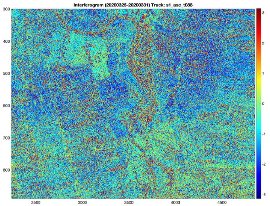
InSAR interferogram (Conroy et al., in preparation)
Contextual Data Integration
A dataset of various contextual data sourced from publicly available data (PDOK) is prepared, which includes cadastral land parcel delineations, land use codes, soil maps, groundwater maps, and groundwater management zones. We spatially average the native 5×20 meter Sentinel-1 observations according to the parcel delineations of the contextual dataset. This is a natural division to make, as the land cover, soil type, and groundwater are approximately consistent within a parcel. This also ensures a high multilooking degree of approximately 100 equivalent looks (although this varies with each parcel according to its shape and size) which aids in suppressing noise.
Following the multilooking step, we perform equivalent phase estimation using the EMI method, which collapses the full complex coherence matrix of all interferometric combinations down to one phase time series per point. Temporal contextual information is also integrated into the dataset in the form of meteorological data from the nearest KNMI station. Each parcel can be assigned a nearest station by means of Voronoi polygonization.
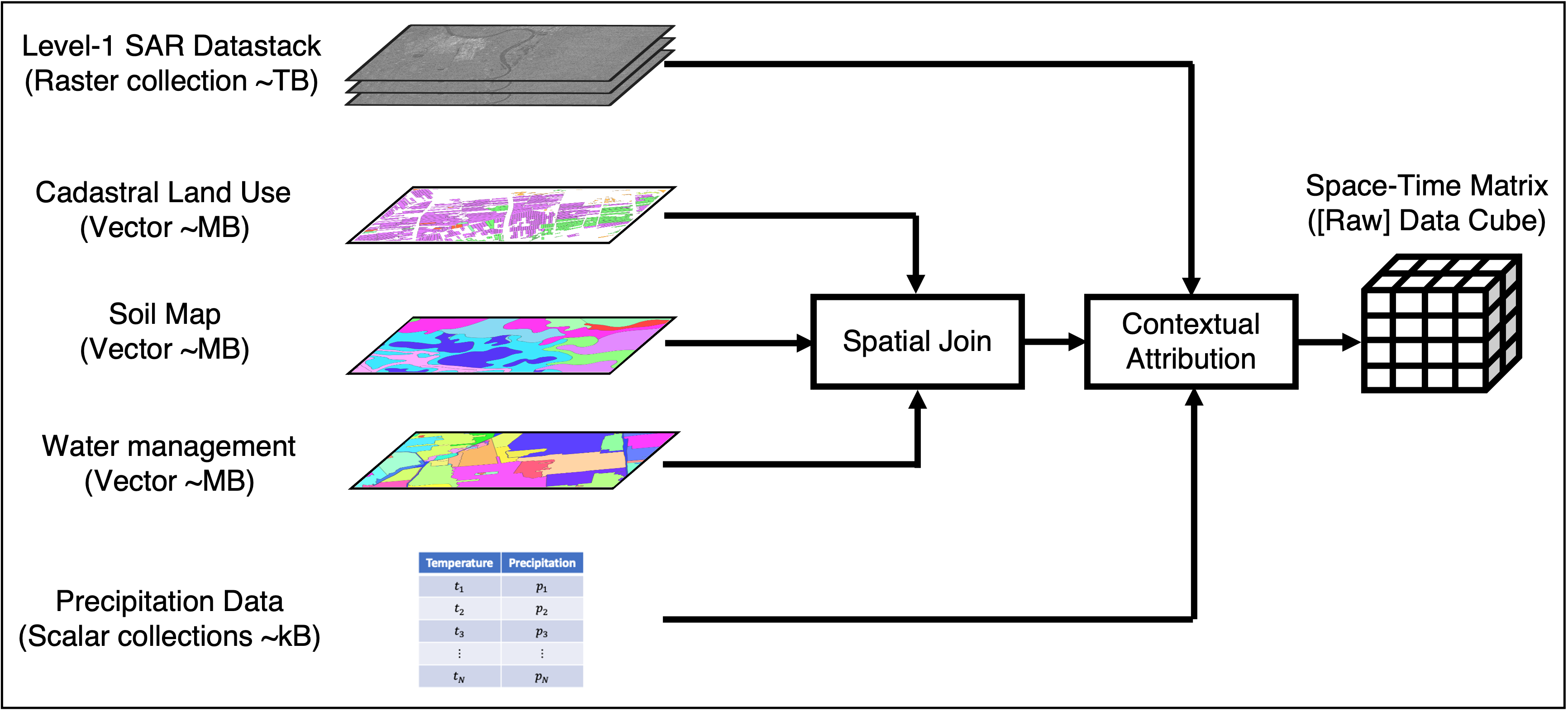
Contextual data processing workflow (Conroy et al., in preparation)
Machine Learning Aided Phase Unwrapping
Rapidly changing displacement phases and noise make the application of standard phase unwrapping algorithms very unreliable, and often large movements in one direction are misinterpreted as smaller movements in the opposite direction. This motivated the development of a machine learning aided phase unwrapping algorithm, described in [1]. The algorithm uses rainfall and temperature data to anticipate large subsidence and uplift events in order to guide phase ambiguity resolution in the temporal domain.
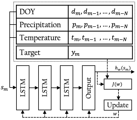
Contextual data processing algorithm (Conroy et al., in preparation)
Research Output as of December 2022 (First Author Only)
Easy-to-read Dutch summaries
Bodembeweging van de Nederlandse veengebieden monitoren met InSAR
Bodembeweging afschatten gebaseerd op meteorologische gegevens met SPAMS
Oplossingen voor signaalverlies in InSAR-tijdreeksanalyse in het veenweidegebied
Journal Papers
Conroy, P., Van Diepen, S. A., Van Asselen, S., Erkens, G., Van Leijen, F. J., & Hanssen, R. F. (2022). Probabilistic estimation of InSAR displacement phase guided by contextual information and artificial intelligence. IEEE Transactions on Geoscience and Remote Sensing, 60, 1-11.
P. Conroy, S. A. N. van Diepen, F. J. van Leijen and R. F. Hanssen, “Bridging Loss-of-Lock in InSAR Time Series of Distributed Scatterers,” in IEEE Transactions on Geoscience and Remote Sensing, vol. 61, pp. 1-11, 2023.
P. Conroy, S. A. N. van Diepen, F. J. van Leijen and R. F. Hanssen, “Bridging Loss-of-Lock in InSAR Time Series of Distributed Scatterers,” in IEEE Transactions on Geoscience and Remote Sensing, vol. 61, pp. 1-11, 2023.
Conference Papers
P. Conroy and R. F. Hanssen, “Towards Automatic Functional Model Specification for Distributed Scatterers Using T-SNE,” 2021 IEEE International Geoscience and Remote Sensing Symposium IGARSS, 2021.
P. Conroy, S. A. N. van Diepen, F. J. van Leijen, and R. F. Hanssen, “Hybrid InSAR processing for rapidly deforming peatlands aided by contextual information,” in 2022 IEEE International Geoscience and Remote Sensing Symposium IGARSS, 2022.
P. Conroy, S. A. N. van Diepen, F. J. van Leijen, and R. F. Hanssen, “First Results of Dutch Peatland Subsidence Observations Using InSAR,” in UNESCO Tenth International Symposium on Land Subsidence TISOLS, 2023.
Conferences
(Oral Presentation) P. Conroy and R. F. Hanssen, “Machine Learning And Data Fusion For InSAR Over Distributed Scatterers,” in ESA Fringe Workshop, 2021.
(Oral Presentation) P. Conroy and R. F. Hanssen, “Direct Observation of Dutch Peatlands in a Mixed Scatterer Interferometry Framework,” in ESA Living Planet Symposium, 2022.
(Oral presentation) P. Conroy and R. F. Hanssen, “Enabling InSAR Observations of the Dutch Peatlands Using Segmented Processing,” in Netherlands Geodetic Commission Symposium NCG, 2022.
(Oral presentation) P. Conroy, F. J. van Leijen, O. Ku, S. van Diepen and R. F. Hanssen, “Contextual Data Driven Solutions for InSAR Processing”, in IEEE GRSS Remote Sensing Data Management Technologies in GeoScience, 2022.