WP1.2 – Disentangeling different sources of subsidence
Introduction
Human induced-subsidence is often the sum of contributions at multiple depths. Shallow causes (up to ~10 meters depth) are amongst others: settlement due to construction of infrastructure and buildings, land use and phreatic water level management, and groundwater withdrawal. The latter can play a role at intermediate depths (10 – ~several hundreds of meters) as well. Deep causes (several hundreds of meters – kilometers) are extraction of salts and hydrocarbons and geothermal production.
Methods
To better understand the contribution of each subsidence process, we combine the various processes that influence the total signal of subsidence into one subsidence model, and we calibrate it with observed subsidence. The observed subsidence consists of measurements at the surface derived from Interferometric Synthetic Aperture Radar (InSAR), levelling and/or GPS data. Our subsidence models include shrinkage of clay, oxidation of peat, creep and compaction, modelled using well established models. The models require input information. This is obtained from lithological models, groundwater models, cone penetration tests and reservoir depletion models.
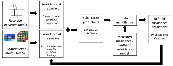
Figure: Overview of the workflow. Shallow and deep causes of subsidence can be combined into one subsidence prediction. This prediction is checked against the observational data to refine the subsidence prediction by optimization of the parameters.
To optimize our subsidence model, the parameters that describe subsurface processes are fitted to the measured subsidence in a Bayesian inversion approach. Ensemble Smoother with Multiple Data Assimilation (ES-MDA) advances our understanding of the spatiotemporal contribution of the different subsidence processes.
The study will yield two important types of results: a novel methodology for subsidence modelling, where several datasets are combined for the first time, and a parameterized description of the subsidence processes for the case studies on which the methodology is applied. A few case studies have already been conducted. In the case study of shallow subsidence contribution in an urbanized reclaimed coastal area (Almere), we have improved our methodology by linking shrinkage of clay could to groundwater fluctuations. Geological and groundwater model have been combined with InSAR data. We conducted a second case study along a highway section in the Friesland coastal plain in the north of the Netherlands. Here, a data assimilation workflow combines cone penetrations tests with InSAR data. The scale of sedimentary heterogeneities has shown to be of major importance to differential subsidence, hence potential damage to infrastructure. In a synthetic case study, we combined real reservoir data with a regional and lithological groundwater model to introduce and test the workflow of disentangling multi-depth subsidence processes with ES-MDA.
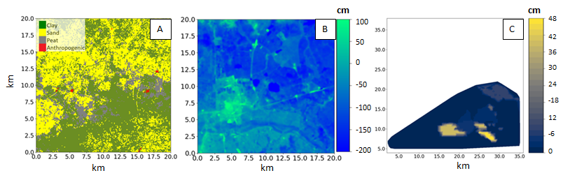
Figure: Overview of example data sources of the project. A: a simplified lithological model, containing sand, peat, clay and anthropogenic. The model is adjusted from the GeoTOP model of www.dinoloket.nl. B: A groundwater model containing the average groundwater level with respect to NAP at the same resolution as model A. The model is constructed as the result of interpolation of available groundwater data from www.dinoloket.nl. C: A gas reservoir depletion model, showing the total pressure change over time in a spatial map view.
For the duration of the project, we aim to develop and apply the workflow to more multi-datatype case studies where multi-depth subsidence processes play a role. Therefore, we have a profound interest in areas where there is observed subsidence that originates from multiple subsidence processes, from which the contribution to total subsidence is unknown. Feel free to contact us: m.a.m.verberne@uu.nl / manon.verberne@tno.nl
People
Manon Verberne is conducting the research of this work package, as part of a PhD project. The project is supervised by Peter Fokker and Kay Koster and work has started 1st of May 2021. The promotor is Hans de Bresser.